Analysis of information sources in references of the Wikipedia article "Estuary of St. Lawrence" in English language version.
The estuary is home to belugas all year round. In summer, the estuary also hosts rorquals and other species of toothed whales that benefit from the abundance of krill, capelin and other small fish.
The abundance of food in the Marine Park's ecosystems attracts many species of birds, whales and seals.
The effect of the tides is faintly perceptible in Lake Saint-Pierre, the last freshwater basin before the estuary
The expert training, precise knowledge and practical experience required of pilots are therefore indispensable for navigating this river.
Interest in working at sea, Excellent spatial perception, Ability to work in crisis situations and under unforeseen circumstances,
The beluga whale frequents different habitats depending on the season and progression of ice breakup and freeze.
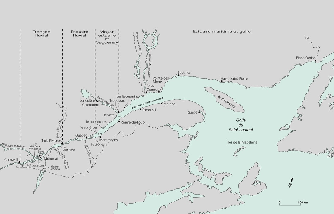
Among the deepest and largest estuaries in the world
The river, which the Amerindians had called "the walking way," was the only communication and transportation route for the pioneers.
Monitoring was carried out between Saint-Augustin-de-Desmaures and Île aux Grues, at 10 sites where at least one of these taxa was present.
Île d'Orléans is located in the upper estuary of the St. Lawrence River, three miles downstream from the city of Quebec
Betula papyrifera Marshall. — Bouleau à papier. — Bouleau blanc, Bouleau à canot. — (Canoë birch).
The estuarine section is the portion of the river under the power of freshwater tides
The coastline of Pointe des Monts on the North Shore and the city of Matane, opposite, in the Gaspé Peninsula, are the points that serve as the boundary between the estuary of the St. Lawrence River upstream, and the much wider Gulf of St. Lawrence, downstream.
The pilot station of the Corporation des pilotes du Bas-Saint-Laurent occupies the northern part of the cove, a 61-metre-long wharf that allows boarding the pilot boat.
Regional landscape units The regional landscape unit is a territory of the order of a thousand square kilometers relatively homogeneous with regard to relief, altitude, geomorphology, hydrography and vegetation
In Canada, the most popular bark for canoe construction has come from the paper birch
Our team is composed of members from the Pekuakamiulnuatsh First Nation
The diversity and number of birds that frequent the area's agricultural, forest and coastal lands are impressive — more than 100 bird species have been recorded in the area.
The width of the Lower Estuary varies from 24 km to Tadoussac 50 km to Pointe-des-Monts
Important source of information on the status of marine resources harvested in the estuary and northern Gulf of St. Lawrence.
The immense Saint Lawrence estuary emerges on the second part of the course, a veritable anti-chamber prior to the open ocean and the Atlantic.
Study several geomorphological events have shaped the landscape of the territory
The one million square kilometre region includes the Canadian portion of the watersheds of rivers that flow into the St. Lawrence River from east of Montreal, into the Gulf of St. Lawrence and into the Atlantic Ocean.
Whale-watching sites for everyone