Analysis of information sources in references of the Wikipedia article "Pratas Island" in English language version.
VHR7 TUNGSHA (PRATAS) ISLAND Circle of 10 NM (18.5 km) radius centred at 2042N 11643E
Since 1949, Taiwan has remained under Nationalist (Kuomintang) control ... In addition, the Nationalists maintain garrisons and weather stations in the South China Sea on T'ai-p'ing Island in the Nansha or Spratly Islands and in the Tungsha or Pratas Islands (see Figure 6.1).
Off-Lying Banks and Islands.
2784 Pratas Reef and Island
This cross-domain cooperation effectively implemented the rat extermination program, and 721 mice were caught on the Dongsha Islands (Pratas Islands) in just one month.
東沙國家公園成立於2007年1月,
Without mentioning China, he expressed India's concern over the nation's aggressive moves in the region, including building military infrastructures in the disputed waters, and purported plan to create an Air Defence Identification Zone (ADIZ) covering the disputed Pratas, Paracel and Spratly Islands.
城区{...}(东沙群岛不是镇建制)
东沙群岛{...}北卫滩{...}南卫滩{...}东沙岛{...}东沙礁
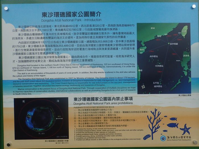
東沙環礁位於南海北部海域,東北距高雄450公里,西北距香港320公里,西南距海南島榆林670公里,南距南沙太平島1,190公里,東南離馬尼拉780公里;行政區域隸屬高雄市旗津區。{...}Dongsha Atoll located in the northern South China Sea is 450 km southwest of Kaohsiung, 320 km southeast of Hong Kong, 670 km northeast of [Yulin on] Hainan Island, 1,190 km north of Taiping Island, [and] 780 km northwest of Manila. Administratively, it is under the Cijin District of Kaohsiung.
民國35年(1946年){...}9月,海軍負責接收東沙島,並設立東沙管理處;東沙氣象台由海軍負責管理。{...}民國43年(1954年){...}秋季,國防部長蔣經國至島上視察.
東引地區 (北固礁、東沙島、雙子礁){...}東引鄉 北固礁 0.2701 0.11 東沙島 5.0434 1.96
Tungsha Island
{{cite book}}: |website= ignored (help)CS1 maint: location missing publisher (link)The Dongsha Islands, administered by Taiwan but also claimed by China, are located about 310 kilometers southeast of Hong Kong and are within its Flight Information Region (FIR).
{{cite book}}: |website= ignored (help)The Pratas Islands, known as the Dongsha Islands in Chinese and located within Hong Kong airspace, comprise one island, two coral reefs and two banks.
The Pratas Reef lies 230 miles to the southwest of the southern tip of Taiwan.26 It consists of an island in the mouth of a semicircular shoal open to the west. The segments D1-D4 close the mouth by connecting the headlands of the shoal with the island.
Located 444 kilometers from Kaohsiung City, the Dongsha, or Pratas, Islands, consist of one island, two coral reefs, and two banks. The islands are administered by Kaohsiung's Cijin District, and Coast Guard personnel are stationed there.
{...}
Former Kaohsiung Mayor Frank Hsieh (謝長廷) made a visit to the Dongsha Islands in May of 1999 for the same purpose, when he hung an address plate on the island's fishing service station. Chen Chu (陳菊), his successor, never visited the islands during her 12-year stint.
The PRC's territorial land includes the mainland and its offshore islands, Taiwan and the various affiliated islands including Diaoyu Island, Penghu Islands, Dongsha Islands, Xisha Islands, Nansha (Spratly) Islands and other islands that belong to the People's Republic of China
The Pratas Islands, known as the Dongsha Islands in Chinese and located within Hong Kong airspace, comprise one island, two coral reefs and two banks.
The Pratas Reef lies 230 miles to the southwest of the southern tip of Taiwan.26 It consists of an island in the mouth of a semicircular shoal open to the west. The segments D1-D4 close the mouth by connecting the headlands of the shoal with the island.
東沙環礁位於南海北部海域,東北距高雄450公里,西北距香港320公里,西南距海南島榆林670公里,南距南沙太平島1,190公里,東南離馬尼拉780公里;行政區域隸屬高雄市旗津區。{...}Dongsha Atoll located in the northern South China Sea is 450 km southwest of Kaohsiung, 320 km southeast of Hong Kong, 670 km northeast of [Yulin on] Hainan Island, 1,190 km north of Taiping Island, [and] 780 km northwest of Manila. Administratively, it is under the Cijin District of Kaohsiung.
The PRC's territorial land includes the mainland and its offshore islands, Taiwan and the various affiliated islands including Diaoyu Island, Penghu Islands, Dongsha Islands, Xisha Islands, Nansha (Spratly) Islands and other islands that belong to the People's Republic of China
The Dongsha Islands, administered by Taiwan but also claimed by China, are located about 310 kilometers southeast of Hong Kong and are within its Flight Information Region (FIR).
城区{...}(东沙群岛不是镇建制)
东沙群岛{...}北卫滩{...}南卫滩{...}东沙岛{...}东沙礁
{{cite book}}: |website= ignored (help)CS1 maint: location missing publisher (link)民國35年(1946年){...}9月,海軍負責接收東沙島,並設立東沙管理處;東沙氣象台由海軍負責管理。{...}民國43年(1954年){...}秋季,國防部長蔣經國至島上視察.
Tungsha Island
VHR7 TUNGSHA (PRATAS) ISLAND Circle of 10 NM (18.5 km) radius centred at 2042N 11643E
東引地區 (北固礁、東沙島、雙子礁){...}東引鄉 北固礁 0.2701 0.11 東沙島 5.0434 1.96
東沙國家公園成立於2007年1月,
Without mentioning China, he expressed India's concern over the nation's aggressive moves in the region, including building military infrastructures in the disputed waters, and purported plan to create an Air Defence Identification Zone (ADIZ) covering the disputed Pratas, Paracel and Spratly Islands.
東沙島則是唯一突出水面的島嶼
東沙環礁位於南海北部海域,東北距高雄450公里,西北距香港320公里,西南距海南島榆林670公里,南距南沙太平島1,190公里,東南離馬尼拉780公里;行政區域隸屬高雄市旗津區。{...}Dongsha Atoll located in the northern South China Sea is 450 km southwest of Kaohsiung, 320 km southeast of Hong Kong, 670 km northeast of [Yulin on] Hainan Island, 1,190 km north of Taiping Island, [and] 780 km northwest of Manila. Administratively, it is under the Cijin District of Kaohsiung.
東沙島則是唯一突出水面的島嶼