Analysis of information sources in references of the Wikipedia article "Qira County" in English language version.
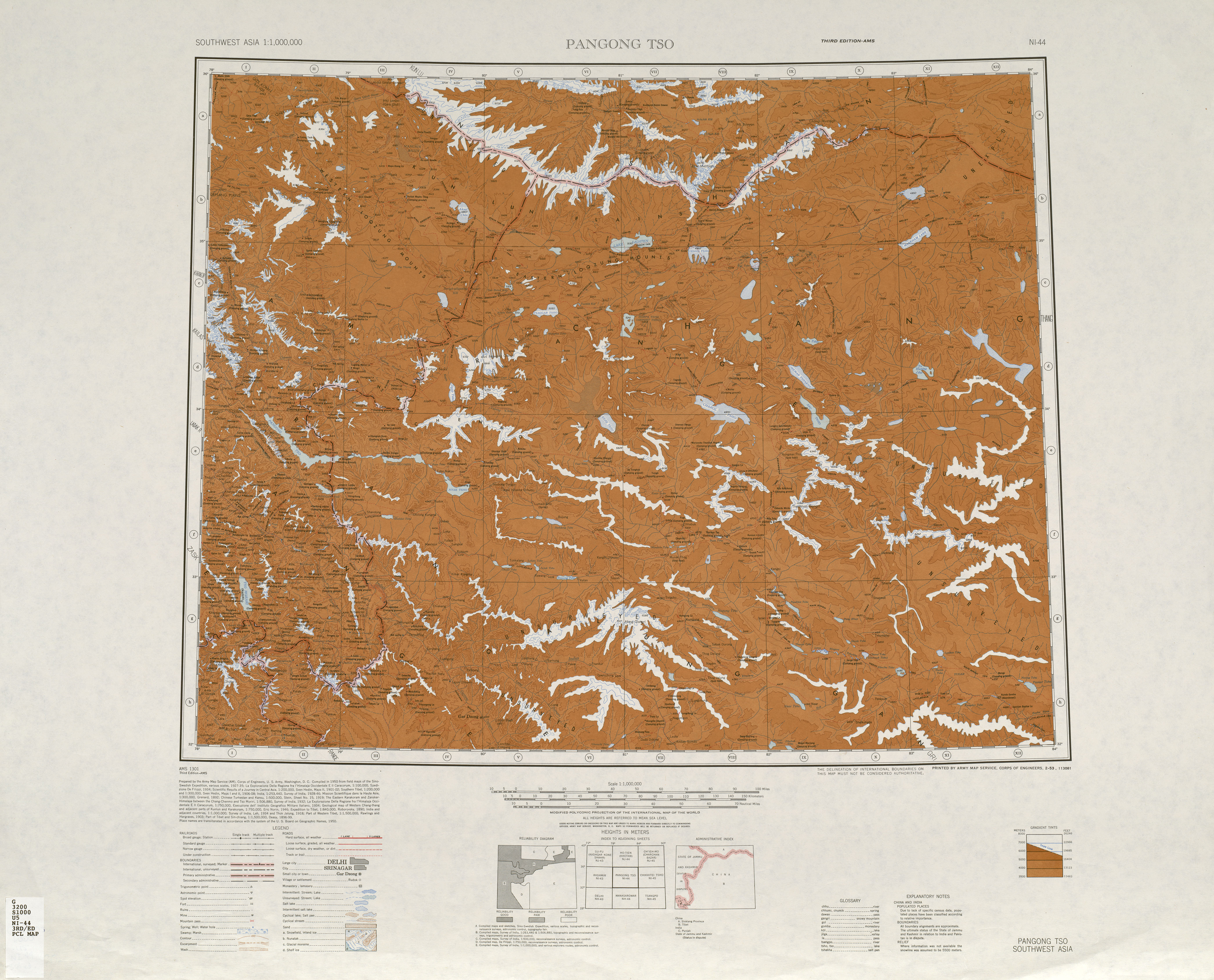
Qira{...}Muztag 7282m
策勒{...}木斯山
We tried in vain to hire camles at Chira, and so went eastward a few miles to Dumuka, a neighboring village, to try again.
Qira county was once a kingdom on the ancient Silk Road in the days of the Eastern Han Dynasty (AD 25-220). The county seat has relocated north three times because the sands have eaten up the cultivatable land. The first relocation occurred more than 2,000 years ago and the most recent about 620 years ago. In the 1980s, the county seat faced yet another relocation because the desert was only about 1.5 km away. Many locals were forced to move because their houses were buried under sand, often overnight.{...}Memet Simay's household was one of 446 in Qira township forced to relocate in the 1980s, although the family has since returned to the area. "When I woke up one morning, I found I couldn't open the door because of the weight of sand that had accumulated overnight. My crops were buried too, so I had no choice but to move," he recalled.
In the 30 years from the 1950s to the 1980s, shifting sand had moved about 5 km in the village of Cele located on the margin of the Cele county oasis, so that 1.333 ha farmland was desertified.
The temple, dating back more than 1,500 years, was located about seven kilometres from the Damagou Township of Cele County.
A second announcement, issued Feb. 28 by the Chira (Cele) county government, said those who report individuals for having "stitched the 'star and crescent moon' insignia on their clothing or personal items" or the words "East Turkestan"—referring to the name of a short-lived Uyghur republic—on their mobile phone case, purse or other jewelry, were also eligible for cash payments.
In March, Xinjiang authorities fired an ethnic Uyghur official for holding her wedding ceremony at home according to Islamic traditions instead of at a government-sanctioned venue. Salamet Memetimin, the communist party secretary for Chaka township's Bekchan village, in Hotan (in Chinese, Hetian) prefecture's Chira (Cele) county, was among 97 officials recently charged with disciplinary violations, according to an April 10 report by the state-run Hotan Daily newspaper. Local residents said the woman was relieved of her duties for taking her "nikah" marriage vows in her own home. "I think this may be a local policy unique to Xinjiang," the source said. "You have to first apply for a marriage certificate and then carry out the Islamic practice of nikah." "The imams aren't allowed to perform nikah if there is no marriage certificate, or they will be sent to prison."
653225100210 220 津南新村村委会
统计用区划代码 名称 653225100000 策勒镇 653225101000 固拉合玛镇 653225200000 策勒乡 653225202000 达玛沟乡 653225203000 恰哈乡 653225204000 乌鲁克萨依乡 653225205000 奴尔乡 653225206000 博斯坦乡 653225500000 兵团一牧场
Some local governments are struggling to maintain this pace of spending. In neighbouring Cele county, where authorities expected to have almost 12,000 detainees in vocational camps and detention centres, a budget for 2018 says: "There are still many projects not included in the budget due to a lack of funds. The financial situation in 2018 is very severe."
DUNES{...}STEIN 1900-01{...}WELL{...}Ts'e-lo Ho{...}WU-LU-KO HO SHAN (MO-SHIH SHAN)
Muztagh Jilga{...}Yurung Kash{...}Chotma (Camping ground){...}Yangi kan (Camping ground){...}Zaiuk (Camping ground){...}Yaskako Tagh (Camping ground){...}Mandar Chap (Camping ground){...}Chumik (Camping ground){...}Mandar Kol Dawan{...}Shalgon Dawan{...}Kuchkash Bulak Dawan{...}Art Dawan
策勒县位于新疆最南端,南枕昆仑山、北临塔克拉玛干大沙漠,县域总面积3.16万平方公里。全县地势总体南高北低,山区平均海拔3200米,平原区海拔1500—1800米。{...}县境内可供人类生存的绿洲面积仅占2.9%,且被沙漠和戈壁分割包围成大小不等的72块,历史上策勒县城因风沙侵袭三次被迫搬迁。策勒县总人口16.8万人,维吾尔族占总人口的98%以上。全县辖6乡2镇1街道,
Memet Azizi, director of Cele County's bureau of education, said that Tianjin's help had brought them hope for the future. With support from Tianjin, a standard football field and training center was constructed at Cele County's No. 1 Primary School.
卧龙谷位于新疆和田策勒县恰哈乡玉如克塔什村,在它的怀抱里,策勒河带着这里人的喜怒哀乐悠悠地流向远方。
策勒{...}木斯山
Memet Azizi, director of Cele County's bureau of education, said that Tianjin's help had brought them hope for the future. With support from Tianjin, a standard football field and training center was constructed at Cele County's No. 1 Primary School.
卧龙谷位于新疆和田策勒县恰哈乡玉如克塔什村,在它的怀抱里,策勒河带着这里人的喜怒哀乐悠悠地流向远方。
策勒县位于新疆最南端,南枕昆仑山、北临塔克拉玛干大沙漠,县域总面积3.16万平方公里。全县地势总体南高北低,山区平均海拔3200米,平原区海拔1500—1800米。{...}县境内可供人类生存的绿洲面积仅占2.9%,且被沙漠和戈壁分割包围成大小不等的72块,历史上策勒县城因风沙侵袭三次被迫搬迁。策勒县总人口16.8万人,维吾尔族占总人口的98%以上。全县辖6乡2镇1街道,
民国17年(公元1928年)2月23日,中华民国政府批准将策勒县佐升格为策勒县治,同年,和阗行政长官制改为和田行政长官公署,策勒县隶属新疆省和阗行政长官公署管辖。中华人民共和国成立初,策勒县隶属新疆省和阗行政公署;1955年10月1日,新疆维吾尔自治区成立,策勒县隶属新疆维吾尔自治区和田地区。
2000年第五次人口普查,策勒县常住总人口132139人,{...}2003年,全县总面积31688.01平方千米,{...}2010年第六次人口普查,策勒县常住总人口147050人,其中:策勒镇14562人,策勒乡31123人,固拉哈玛乡26621人,达玛沟乡19250人,恰哈乡15010人,乌鲁克萨依乡4587人,奴尔乡11581人,博斯坦乡6626人,色日克街道15684人,兵团一牧场2006人。 2014年10月20日,自治区政府(新政函[2014]177号)同意撤销固拉合玛乡,设立固拉合玛镇。调整后,全县辖2个镇、6个乡:策勒镇、固拉哈玛镇、策勒乡、达玛沟乡、恰哈乡、乌鲁克萨依乡、奴尔乡、博斯坦乡。
和田地区辖县。位于昆仑山北麓、塔克拉玛干沙漠南缘。面积3.6万平方千米,人口12.6万,有维吾尔、汉、回、藏、壮等民族。其中维吾尔族占98.4%,辖1镇7乡。
辖4个农牧团场(皮山农场、一牧场、47团、224团),其中{...}一牧场驻策勒县、